Daocheng Yading: Three Sacred Peaks and the Milk Lake Hike
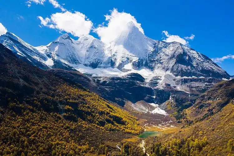
Daocheng Yading is a high valley in western Sichuan where three peaks of about 5,950 to 6,030 m stand over glacial lakes, pastures and a working Tibetan monastery. The names most travellers learn are Xiannairi (Chenrezig), Yangmaiyong (Jampayang) and Xianuoduoji (Chanadorje) — the three bodhisattvas of Tibetan Buddhism — and the whole reserve is arranged around looking at them rather than climbing them. The valley floor is already at 3,900 to 4,000 m.
It is also harder than the photographs suggest. The lakes sit at 4,600 to 4,700 m, the walk in is real walking, and the airport most people use is at 4,411 m. This guide covers the trails, the altitude, the September window and the culture, and leaves the rest of the province to the best scenic spots in Sichuan.
Daocheng Yading at a glance
| Location | Daocheng County, Garzê Tibetan Autonomous Prefecture, western Sichuan, roughly 800 km from Chengdu by road |
|---|---|
| Nearest airport | Daocheng Yading Airport at about 4,411 m, then 2 to 3 hours by road to the gate at Riwa |
| Best months | Late September to mid-October; June as a quieter, greener second choice |
| Days needed | Three days inside the reserve, plus one or two nights to acclimatise |
| Tickets and rules | About ¥146 entry plus about ¥120 shuttle in peak season; passport and real-name booking; check current rules for Tibetan areas |
Three peaks, one valley
Xiannairi, at about 6,030 m, is the peak that dominates the head of the valley above Chonggu Monastery, a white pyramid that turns pink at sunset. Yangmaiyong and Xianuoduoji, both a little under 5,960 m, appear as you move up towards Luorong pasture: one broad and heavily glaciated, the other sharper and more broken. All three are sacred, and none is open to climbing.
That last point is not a formality. Tibetans come here on pilgrimage, walking clockwise around Xiannairi on a kora that takes about three days and crosses a pass above 4,500 m. You will meet them on the lower trails, often in family groups, and the monasteries and stupas are active religious sites rather than exhibits. Walk clockwise around them, give prayer flags room, and ask before taking portraits.
The name Yading is often translated as "the last Shangri-La", which is marketing rather than geology. What is true is that there is no road beyond Yading village, the forest is old, and the dawn light hits the snow in stages. It is quiet early and loud by eleven.
Inside the park: what the trails actually are
Everything starts at the gate near Riwa, where you take a park shuttle up to Yading village and on to Chonggu Monastery at about 3,880 m. The first day is deliberately easy: a boardwalk loop from the monastery to Pearl Lake, a small green tarn directly under Xiannairi, about 30 to 40 minutes each way. It is the best short walk in the park and the right place to test how your body is handling the height.
The second day is the hard one. A shuttle runs from the village to Luorong pasture at about 4,180 m, a flat meadow with a river braided through it and the two remaining peaks lined up behind. From there the trail climbs through forest and then open slope to Milk Lake at about 4,600 m, roughly 5 km each way, and a further 20 to 30 minutes of steeper switchbacks to Five Color Lake at about 4,700 m. Round trip from Luorong is 10 to 12 km and six to eight hours for most people.
Two things catch people out. The last shuttle down from Luorong leaves in the late afternoon, so an ambitious start is not optional. And the weather changes fast: sun, then hail, then sun again within an hour. A shell and a warm layer belong in your day pack even on a blue morning.
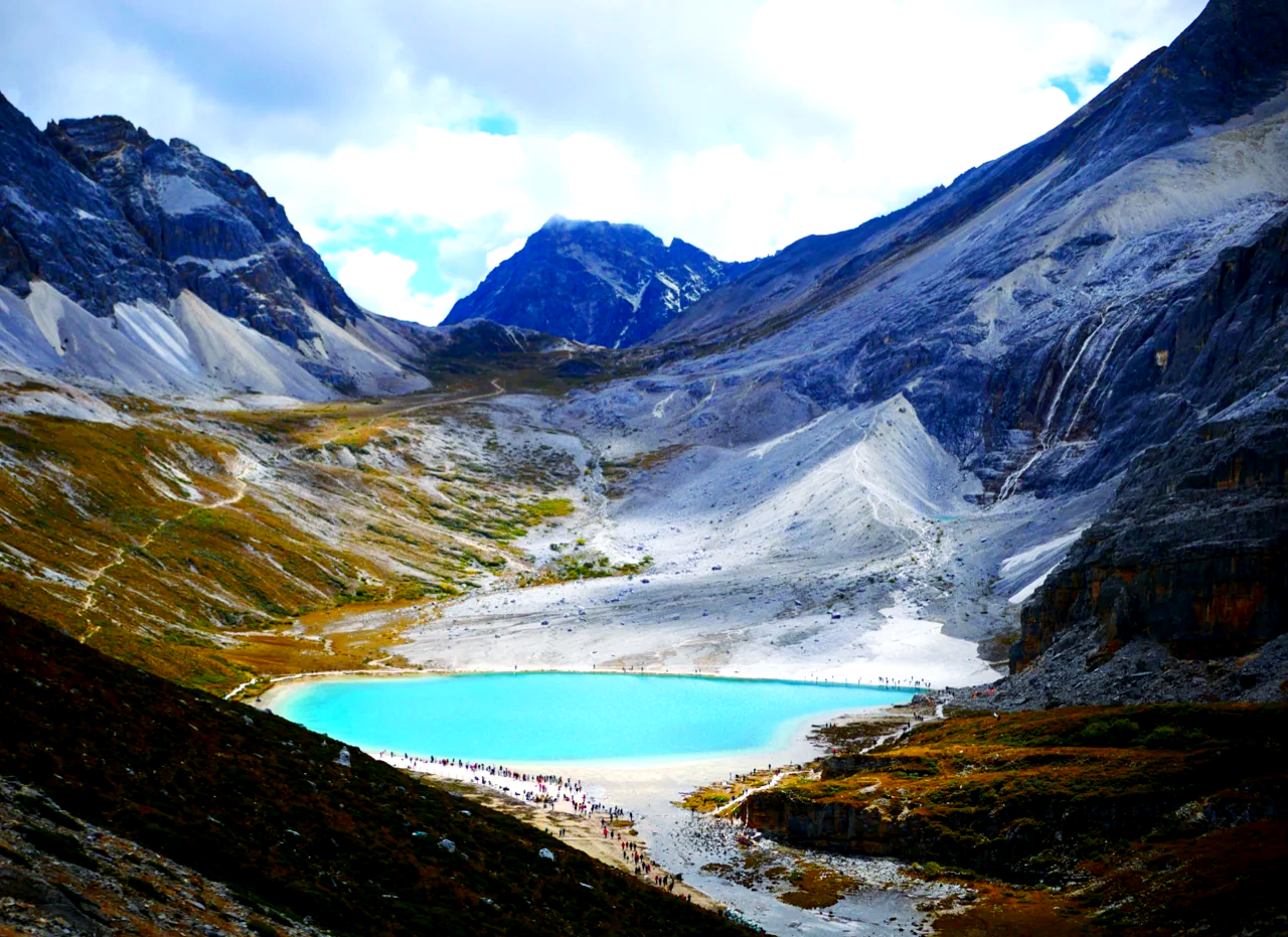
Horses are available from Luorong for part of the climb, in limited numbers, sold early, and they stop below Five Color Lake. A paid electric cart shortens part of the approach when it is running. Neither removes the walking entirely. If you want a longer trek in the same region with a different shape, the Mount Gongga hiking guide covers the classic routes around Sichuan's highest peak.
Altitude: the part nobody enjoys
This is why people have bad trips here. Daocheng Yading Airport sits at about 4,411 m, among the highest civil airports anywhere. Flying up from Chengdu at roughly 500 m means a jump of nearly four kilometres in an hour. Some people are fine; some spend the first day with a headache, nausea and no appetite; a few need to descend.
Give yourself a night at Riwa, about 3,100 m, or in Daocheng town at 3,750 m, before entering the park. Walk slowly on arrival, drink more water than feels necessary, skip alcohol, and treat a resting heart rate that stays high as a warning rather than a curiosity. Oxygen canisters help with symptoms but do not fix the cause; descent does.
If you are driving from Chengdu, the ascent is gradual and the risk is lower: Kangding at about 2,560 m, then Xinduqiao or Yajiang, then Daocheng. See the best places in southwest China for what lies either side of the road.
When to go
| Period | What you get | Reality |
|---|---|---|
| May–June | Rhododendrons, snow still low, few visitors | Changeable cloud; some high trails still icy |
| July–August | Green pasture, wildflowers, longest days | Rain, mud, peak domestic crowds |
| Late September–mid October | Golden larch, clear air, sharp peaks | The best window; book everything early |
| Late October–November | Empty trails, early snow | Cold nights; services start closing |
| December–April | Deep winter quiet | Trails to the lakes often unsafe or shut |
Late September to mid-October is the window that justifies the journey: the larches turn, the monsoon has gone, and the peaks are visible for whole mornings. The first week of October is the busiest week of the year, so aim for the second week if you can. June is the underrated option — fewer people, water in the streams, cloud that lifts in the afternoon.
Getting there, tickets and where to sleep
By air. Flights from Chengdu take about an hour, with seasonal services from other cities. Morning departures are more reliable; afternoon winds at that altitude cancel flights often enough that you should not plan a tight connection.
By road. Chengdu to Daocheng via Kangding and Litang is roughly 800 km and two long days, or three with stops. Shared vans and private drivers are easy to arrange in Chengdu, and the drive is the acclimatisation.
Tickets. Budget about ¥146 for entry plus about ¥120 for the shuttle, and ask at the gate about second-day re-entry, because the policy changes and the discount is not automatic. Book online in advance with your passport in October. Yading is in Sichuan, so the Tibet Autonomous Region permit is not the issue; rules for Tibetan areas do change, so check current requirements rather than trusting an old forum post. The China visa guide covers the entry side.
Where to sleep. Riwa is the practical base: ten minutes from the gate, plenty of guesthouses, and low enough to sleep well. Yading village inside the park puts you above 3,900 m with sunrise on the peaks, but rooms are cold, food is basic, and sleeping at that height is harder. Daocheng town is 1.5 hours away and better stocked. Compare it with Jiuzhaigou, which is far more developed and far easier on the lungs.
Tibetan culture, done respectfully
This is a living Tibetan valley, not a theme park. The monastery at Chonggu is active, the kora path around Xiannairi is a pilgrimage route, and the villages are private homes. Keep your voice down in prayer halls, walk clockwise around stupas and mani stones, do not step on or remove prayer flags, and ask before photographing people or religious ceremonies.
Take your rubbish out, including the wrappers that fall out of a day pack at 4,600 m. Do not fly a drone around the monasteries or the villages. Expect cold rooms and simple food: this is a working valley, not a resort, and the people who live there are not performing for visitors.
Where to go next
If Yading's altitude appeals but its logistics do not, Mount Siguniang offers shorter valley walks at a gentler height. The best national parks in China puts Yading in context with Jiuzhaigou and Zhangjiajie. For more Tibetan plateau scenery, continue west on the Yunnan travel guide route through Shangri-La, and for a broader shortlist see the most beautiful mountains in China.
Frequently asked questions
How hard is the hike to Milk Lake and Five Color Lake?
It is a 10 to 12 km round trip from Luorong pasture, climbing from about 4,180 m to 4,700 m. Most people take six to eight hours with rests. The distance is ordinary; the altitude is what makes it hard.
Do you need a permit for Daocheng Yading?
Not the Tibet Autonomous Region permit, because Yading is in Sichuan. Rules for Tibetan areas change, so check current requirements before you book, carry your passport, and expect real-name booking for park tickets.
Is it better to fly to Daocheng or drive from Chengdu?
Flying is faster but lands you at about 4,411 m, which is brutal for acclimatisation. Driving from Chengdu takes two or three days and lets you sleep at intermediate heights. If you fly, give yourself a night in Riwa before entering the park.
When is the best time to visit Daocheng Yading?
Late September to mid-October, when the larches turn and the sky is usually clearest. June is quieter with rhododendrons but more cloud. July and August are green, wet and busy, and winter closes parts of the high trail.
Can you ride a horse to the lakes?
Only on part of the route, from Luorong towards Milk Lake. Numbers are limited and the queue forms at dawn, the price is several hundred yuan, and horses do not go up to Five Color Lake. You still walk for an hour or more.
How many days should you spend in Yading?
Three days inside the reserve: one for the short Pearl Lake loop, one for Milk Lake and Five Color Lake, and one spare for weather. Add one or two nights before that for acclimatisation at Riwa or Daocheng.
Keep reading
Nature & Parks
National Parks in China: What the Designations Actually Mean
Two systems, and why the confusion matters Search for "national parks in China" and you will get a list that …
Nature & Parks
Kanas Lake: Hemu, Baihaba and the Autumn Window in Xinjiang
Kanas is a long, cold lake at about 1,370 m in the far north of Xinjiang, roughly 24 km from end to end and …
Nature & Parks
15 Natural Wonders in China: Karst, Desert, Lakes
The honest answer to "what should I see in China" is not a list of cities. It is a set of landscapes that do …